

The Serpent Property formerly consisted of 10 mining claims covering approximately 1,840 hectares in Joubin and Gaiashk Townships, Sault Ste. Marie mining division, Ontario. However, since the reorganization and updating of the mining lands system by the Ministry of Northern Development and Mines it now consists of 125 cells covering about 1840 hectares. It is located about 115 km west of the major mining centre of Sudbury and about 10 km east of Elliot Lake, Ontario
The property can be accessed in several different ways. The Algom – Nordic Mine road joins highway 108 south of Elliot Lake and it traverses the entire claim group ending at Whiskey Lake (figure 3). A secondary road known as the Massey tote road branches northward from highway 17 in the village of Massey. This road passes by Whiskey Lake and the lake can be accessed by a public boat launch. The claims can be reached by a short boat trip across the lake. A logging road starts at highway 17 in the village of Spanish and it stops within about 100 metres of a power line road that crosses the claims and connects with the Algom – Nordic road. The Elliot Lake airport is located about 7 km west of the claims providing a base for access by helicopter.
The climate in the area is typical of a northern mid continental climate with summers varying between cool and moist to hot and dry. Winters typically last for 4-5 months and the average temperature is about -9 degrees Celsius but can reach lows of -20 degrees Celsius. The average summer temperatures are about 12.5 degrees Celsius but can reach temperature highs of about 25 degrees Celsius. The average rainfall is about 350 mm and the average snowfall is around 240 mm. Mining operations have operated all year in the past and climactic conditions should not impede the ability to carry out exploration and mining activities.
The city of Elliot Lake has a population of about 13,500 and is connected to highway17 (trans Canada) by highway 108. The city can provide a range of facilities including accommodation, hydro, natural gas and others. Sudbury a major mining area is located about 135 km to the east and provide a comprehensive package of mining and exploration infrastructure. A major power line crosses the claims along the southern boundary.
The topography can be divided into two areas. The area north of the Serpent river is rugged and can reach elevations of up to 425 metres while the area south of the river has a more subdued topography with elevation of about 350 metres.
Vegetation is typical of the boreal forest with higher elevation populated by birch, pine , spruce poplar and maple while the lower lying areas cedar, balsam and tamarack are common.
8.0 HISTORY
In 1953 – 54 Rio Algom Mines conducted a program of geological mapping, prospecting followed by diamond drilling. They drilled a total of 2,120 metres in 30 holes. This was followed by another round of drilling in 1956 and 1957 and a summary of this work (Pountney, 1958) indicated that 4,810 metres were completed in 44 holes. This drilling outlined a mineralized zone called the Pecors Channel.
The eastern portion of the property was explored by British Columbia Explorers, Chibougamau Mines Ltd. and Panel Uranium Mines Ltd… Collectively they drilled 15 holes totalling 1383 metres that discovered a mineralized zone called the Whiskey Lake Channel.
In 1977 Rio Algom compiled a listing of ore estimates on their Elliot Lake properties. This work indicated that the Pecors channel contained 20,000,000 tons grading 0.74 lbs U3O8 per ton. None of the supporting data for this estimate was available for review. This estimate is viewed as an historical resource only and the figures cannot be relied upon as an accurate estimate of the volume of mineralized material nor the grade of the resource.
Robertson, mapped Joubin and Gaiashk Townships for the Ontario Department of Mines in 1961 and 1962 respectively.
In 1991 Jensen published the results of a mapping program on the West and East portions of the Whiskey Lake greenstone belt for the Ministry of Northern Development and Mines. These maps cover portions of the Montoro claims.
In 2010 the Ontario Geological Survey reported on the results of a lake sediment sampling program that covered the property as part of a regional sampling program covering a much larger area (Dyers, 2010). A Ni, Cu, Co anomaly in Pecors lake was attributed to possible leakage from a mineralized zone at depth.
The most recent mapping in the area was by Easton (2013) who published a 1:20,000 scale coloured map of the Pecors-Whiskey area. The entire Montoro claim block is contained within the confines of this map.
International Montoro Resources Inc. completed two drilling campaigns during 2007 and 2010 to test the uranium potential of the Pecors and Whiskey channels in the Huronian sediments. They also carried out an airborne VTEM EM and magnetometer survey over their claims in 2009 which led to the generation of interest in the Pecors magnetic anomaly.
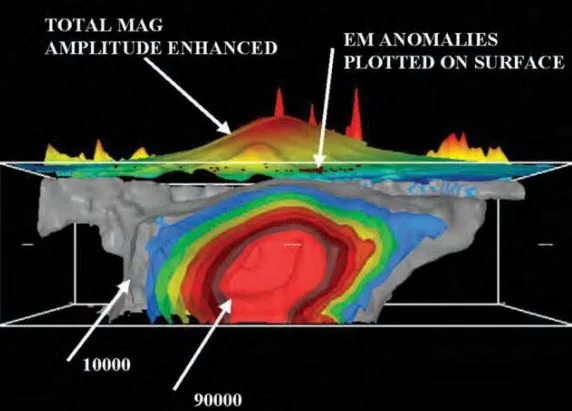
International Montoro Resources decided to switch their exploration efforts from uranium to base metals based on the results of the VTEM survey and the lake sediment sampling program. Accordingly, in 2011 they commissioned consulting geophysicist L. Reid to undertake an inversion of the magnetic data in an attempt to model the source for the anomaly. He modelled a source body that started 300 to 450 meters below the surface and a bottom that extended as much as 1700 metres below the surface.
The Elliot Lake group hosts the uraniferous quartz pebble conglomerates that were mined in the past at Elliot Lake. The Huronian rocks have generally been subjected to low grade metamorphism. Anorthosites and gabbros and some felsic intrusions cut the Huronian sediments.
All of the rocks on the property lie on the southern limb of the Quirke Lake syncline.
Robertson published maps of Joubin and Gaiashk Townships in 1961 and 1962 respectively. Easton (2013) also mapped the area for the Ontario Geological Survey.
The southern part of the property is underlain by an Archean assemblage of mixed metavolcanic and metasedimentary rocks known as the Whiskey Lake greenstone belt. These rocks strike at about 28s and dip to the north at 40 – 70 degrees. The greenstones were intruded by Archean gabbroic sills some of which carry Cu-Ni-PGE mineralization.
Huronian Proterozoic sediments and volcanics unconformably overlie the greenstone assemblage and they consist dominantly of quartzite, argillite and greywacke with thin interbeds of conglomerate and some mafic volcanic rocks at the base of the section. The pyritic conglomerates contain uranium mineralization. Robertson (1962) grouped these rocks into the Mississaugi formation while Easton (2013) included them as part of the Matinenda formation. Easton (2013) mapped Huronian mafic metavolcanic flows (Thessalon formation) at the base of the Huronian and overlying the Archean greenstones in places but the differentiation of the two in core is very difficult and their presence on the property could not be definitively determined (only inferred) during the 2007 and 2010 drill campaigns but they were identified during the2015 drill program. The Huronian rocks dip 20 to 35 degrees to the north.
Lamprophyre and aplite sills, cutting the sediments, were noted in the drill core but their presence at the surface was not noted by Robertson (1962) or by Easton (2013) despite their widespread occurrence.
Poutney (1958) reported on the status of exploration in the area and noted that 4810 metres of drilling had defined a mineralized channel in Matinenda quartzites and quartz pebble conglomerates called the Pecors channel located on the east side of Pecors lake and partially underlying the Serpent River claims.
A number of companies conducted limited work around the west end of Whiskey Lake and discovered a mineralized channel in the same lithologies as the Pecors channel called the Whiskey channel. This channel is also located on the Serpent claims.
The Huronian rocks have been repeated by two thrust faults (Batty Lake thrust and Whiskey Lake thrust) that cut across the property in a Southwesterly direction. Robertson (1962)
24
postulated that the displacement on the Whiskey lake fault is about 650 metres (north side up) while the displacement on the Battey Lake fault is about 850 metres (north side up) The Pecors Fault follows the length of Pecors Lake in a northwesterly direction and it is a major structural feature in the area. It appears to truncate the whiskey Lake fault Robertson (1986) indicates that the location of the fault corresponds with a basement topographic high.
The 2007 and 2010 drilling campaigns by International Montoro Resources focused on the Pecors and Whiskey channels (figure 5) and they intersected pyritic and sericitic quartz pebble conglomerates varying from < 1 to 12.5 metres thick near the base of the Matinenda formation (photo 2). Thin (1-4 mm) dark grey to black horizons (reefs) were also intersected in coarse grained quartzites near the conglomerates that were also mineralized. Uranium grades in the conglomerates and the reefs ranged from 42 to 1240 ppm and were within the same general ranges as reported by Rio Algom in their resource calculations. When the price of uranium retreated from their record highs the company focus turned to other targets on the property.
The drill programs also intersected sill like aplite and lamprophyre intrusions cutting the sediments. Lamprophyres exhibited chill margins against the sediments and showed little evidence of contact metamorphism. The aplites on the other hand showed clear evidence of metasomatic alteration of the sediments and they have remobilized some of the uranium mineralization in places.

Property Geology modified after Cochrane and Roscoe 2007.
International Montoro resources conducted three drilling campaigns, totalling 5944 metres on the property during the period 2007 to 2015. Details of this work will be discussed further in section 13.
Following the first drilling campaign the Company commissioned Geotech Ltd. To conduct and airborne time domain electromagnetic and magnetic (VTEM) survey over the property. The objective of this work was to outline the various lithologies and structures underlying the claims and to identify any conductive horizons that may have a source in the sediments or in the underlying basement rocks and to delineate any areas that could hold the potential to host high grade hydrothermal type uranium mineralization.
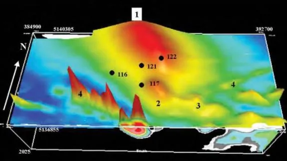
 Total Magnetic field map modified after Geotech 2008
The Nipissing diabase dikes were highlighted by magnetic high anomalies that appear to be displaced in places by northwest trending fault zones. A large strong magnetic high anomaly was outlined in the northwest section of the property and the source for this anomaly was interpreted to be a lithology(s) in the basement rocks.
Conductive EM anomalies were interpreted as due to surficial features (lake bottom clays, silts etc.) or to sources within the sediments. Some anomalies in the southwest corner of the property were due to ironformation within the Archean volcanic rocks and their importance was dismissed as not favourable for hosting uranium mineralization.
A second drilling campaign was initiated in 2010 to further investigate a highly altered and mineralized heterolithic breccia unit containing enriched uranium and thorium (up to 1420 ppm U and 1100 ppmTh) values interpreted to be the result of hydrothermal processes
Following the second drilling program the price of uranium plunged and exploration for uranium was discontinued.
In 2010 the Ontario Geological Survey conducted a regional lake sediment survey over a large area that included the claim group. Anomalous base metal values were detected in Pecors Lake sediments that were interpreted to be the result of leakage from a buried source. This coupled with the strong magnetic anomaly outlined nearby during the VTEM airborne survey prompted the company to resume work focusing on the potential for magmatic Cu, Ni, PGE mineralization.
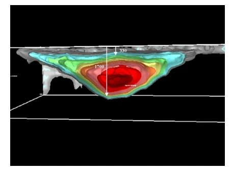
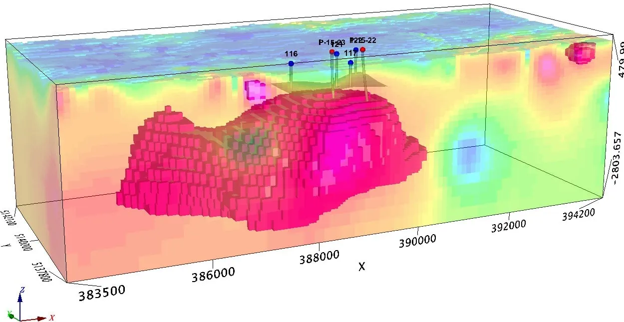
In 2011 the company engaged L. Reed a consulting geophysicist to carry out a 3D inversion of the airborne magnetic data to try and image the source. Reed (2011) concluded the following “ the shape of the main magnetic body is approximately a trough with relatively flat top, a deep keel plunging to the north with thinning edges all around. The thickest part of the body is from 1000 to 1300 metres thick. The top is between 300 and 450 metres from surface”. An East-West and a North-South section through the model showing interpreted depths to the top and bottom of the model are presented in figures 9 and 10.

East-West section through the model looking south. The suggested depths to the top and bottom of the model are indicated. From Reed 2011.

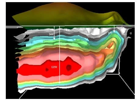
A north-South section through the model looking east. The suggested depths to the top and bottom of the model are indicated. From Reed 2011.
In 2014 the company again engaged Reed to review the VTEM data in the vicinity of the magnetic anomaly to see if there were any electromagnetic responses in the data that could be attributed to a source at depth and possibly coincident with the imaged data from the inversion. He concluded that some EM anomalies detected over the magnetic body have a source at depth but not as deep as the magnetic body while others are due to surficial sources such as lake bottom sediments (Reed , 2014).
The results obtained by the work on the magnetic anomaly were deemed to be sufficiently encouraging to merit additional work and accordingly in 2015 a third drilling campaign was launched that was designed to penetrate the Huronian sediments and intersect the source of the magnetic anomaly. Two deep drill holes were completed and both intersected gabbroic rocks beneath the sediments. One of the holes encountered anomalous Cu – Ni – PGE values in
34
the gabbro. The details of this work will be discussed in more detail in section 13. Samples of the gabbro were subjected to petrographic analysis by Ronacher McKenzie Geoscience and the gabbro was found to be almost completely metamorphosed with only some relict modal feldspar remaining. Sulphide mineral assemblages included pyrrhotite, chalcopyrite, pyrite and pentlandite and some appear to be remobilized (Ronacher, 2015).

Photomicrograph of core section from a depth of 920 metres in hole P-15-22. Cpy (chalcopyrite), Po (pyrrhotite), pent (pentlandite). From Ronacher 2015
At the completion of the drilling downhole electromagnetic geophysical surveys were conducted on holes P-15-22 and P-15-23 by Lamontagne geophysics and Crone geophysics respectively. No significant results were obtained from the Lamontagne survey but two off hole anomalous responses were detected by Crone Geophysics during their work on hole P-15-23.
35
One anomaly was detected in the Huronian sediments and is interpreted to be caused by pyrite mineralization in quartz pebble conglomerate. The other anomaly was deeper in the hole in the gabbro and its source is unknown.

Crone EM anomalies in hole P-15-23. From crone 2015
Representatives from the Ontario Geological survey collected some samples from the core for geochronology. They determined that the gabbro had an age of 2480 Ma. Which is in the same age range as the Matachewan dike swarm and some of the East Bull Lake intrusions.
Geotech Ltd. (Legault, 2017) carried out some synthetic modelling to see if potential sulphide accumulations could be detected at depth on the property. The results suggested that > 7.5 Mt Ni-Cu deposit at depths of 700 to 2100 metres could be detected as anomalies using the ZTEM survey method.
Having confirmed that the source of the magnetic anomaly was due to lithologies favourable to host Cu – Ni – PGE sulphide mineralization and that a possible source deposit could be detected, the company again engaged Geotech to conduct a deep penetrating telluromagnetic survey (ZTEM) over the anomaly to search for conductors that could be associated with sulphide accumulations and that would provide a target for additional drilling (Legault, 2018).
The ZTEM survey provided more complete coverage of the magnetic data that could be combined with the EM data and the company commissioned Geotech to completed a 3D inversion of the EM and magnetic data. This work indicated that there was a deep conductive source that could be coincident with the gabbro intersected during the third drilling program.
Following this work the company engaged Mira Geoscience of Vancouver to construct a 3D computer aided imaging compilation of all existing geophysical and drilling data.

Mira Geosciences 3D compilation results.
Uranium and thorium occur within the Huronian Supergroup at a number of localities in the region. Most of the occurrences are in conglomerates, but some are in coarsegrained quartzite referred to locally as “grit”, and in quartzite and argillite. The only deposits known to contain uranium in sufficient grade and tonnage to be economically viable, however, are in the lower part of the Matinenda formation within about 40 m of the basement. The majority of the exploitable uranium deposits occur in the Elliot Lake area. The Pronto Mine is located in the Blind River area and the Agnew Lake Mine is located about 60 km west of Sudbury.


The location of these deposits and occurrences
Serpent River Project, Elliott Lake ON – ZTEM Natural field Helicoper EM & Magnetic Survey – September 28, 2018
Crone Pulse-EM Geophysical Survey & Logistics Report by Crone Geophysics & Exploration Ltd. – September 2015
Logistics Report on a BH UTEM 4 Survey by Lamontagne Geophysics Ltd. – June 2015
Powerpoint – International Montoro Resources Corporate Presentation – February 2015
Authors:
Lawrence B. Cochrane, Ph.D., P.Eng.
William E. Roscoe, Ph.D., P.Eng.
Technical Report On the